
Introduction of Toshima Village
Profile of Toshima Village
Location
Toshima Village comprises a chain of twelve islands dotting the waters between Yakushima and Amami Oshima islands. The archipelago, called the Tokara Islands, consists of seven inhabited islands (from north to south: Kuchinoshima, Nakanoshima, Suwanosejima, Tairajima, Akusekijima, Kodakarajima, and Takarajima) and five uninhabited islands (Gajajima, Kogajajima, Kojima, Kaminonejima, and Yokoatejima). As a permanently inhabited municipality stretching over an area of about 160 kilometers, Toshima is “Japan’s longest village.”
Climate
The climate of Toshima Village lies between the subtropical and temperate zones, with an average annual temperature of 20º Celsius. The weather is warm and nearly all areas are frostless. The annual rainfall is about 2,700 millimeters.
Seven inhabited islands
Kuchinoshima
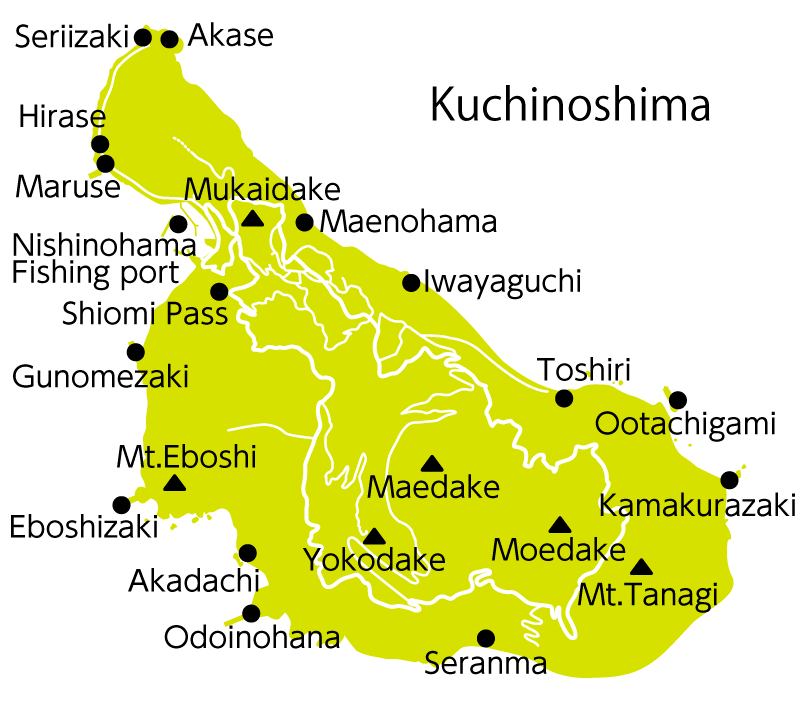 Kuchinoshima is the first stop of the village-operated Ferry Toshima, departing from Kagoshima Port, and serves as the gateway to Toshima Village. The northernmost of the Tokara Islands is a volcanic island, where Moedake continues to emit steam today. The virgin forest leading from the foot of Maedake (628 m), standing roughly in the center of the island, to the Seranma Onsen spa area is the habitat of feral cattle representing a pure-blooded strain of the Japanese Black. And to the west of Maedake, a paved trail provides access to the summit of Yokodake (501 m), commanding a view of the Tokara Islands.
Nakanoshima
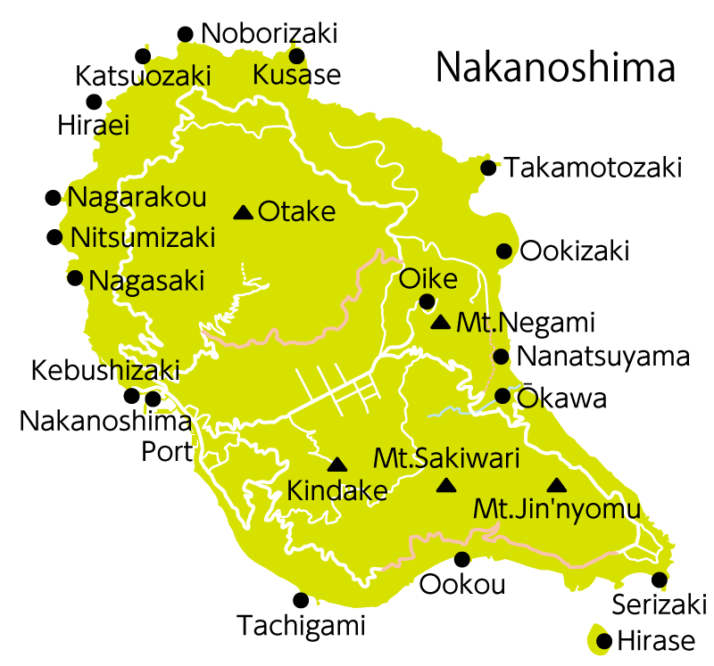 Nakanoshima is the largest island of Toshima Village in both area and population. A branch of the village office, situated near Nakanoshima Port, plays a central role in public administration. In the island’s north-center stands Otake (979 m), the highest peak of the Tokara Islands with a picturesque outline worthy of the label “Tokara Fuji.” The plains in the foothills are the leisurely grazing grounds of the Tokara Pony, designated a natural monument of Kagoshima Prefecture. And the observatory nearby is furnished with a 60-inch reflecting telescope—one of the largest in the Kyushu region—that offers a spectacular view of the cosmos beyond the clear air.
Suwanosejima
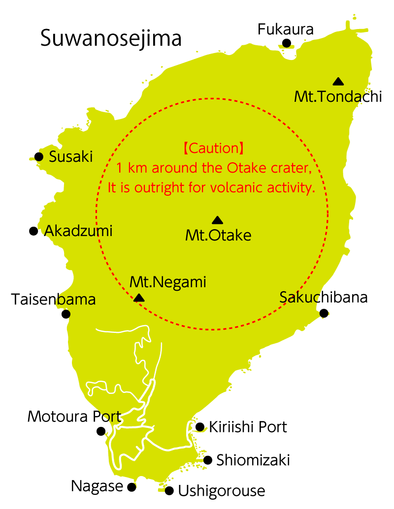 Suwanosejima is the second largest island of Toshima Village. Otake (799 m) is an active volcano that continues to emit fumes today. In the past it recorded numerous great eruptions, with that of 1813 destroying most homes and forcing all islanders to evacuate, leaving the island uninhabited for some 70 years. In the Meiji period (1868–1912), the island was resettled and developed by Fujii Tomiden and others from Amami Oshima. Despite the harsh natural environment, the northwestern lava plateau is covered in a blanket of pink by a colony of maruba-satsuki azaleas come springtime.
Tairajima
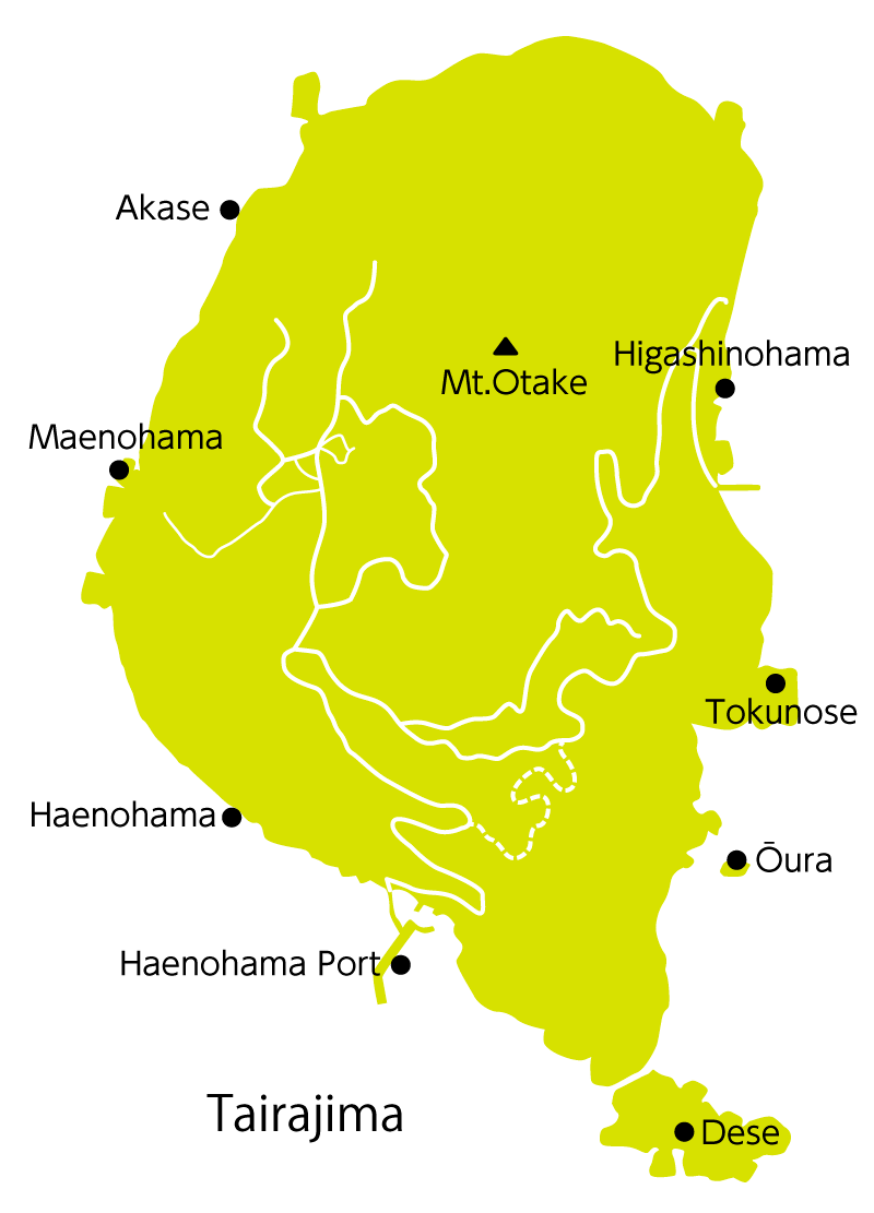 Tairajima is situated in the center of the Tokara Islands. Legend says it was the first haven of warriors of the Taira (Heike) clan, defeated in the Genpei War (1180–85). In a testament to history, under the cliffs of the eastern shore is a cave called Heike-no-ana (Heike pothole), and across the island are the remains of towers from which the fugitives are said to have kept a lookout for pursuers. Old customs are observed most faithfully on Tairajima, and festivals are organized around the lunar calendar. This is the only island of the Tokaras where the coming-of-age ceremony of medieval Japan is preserved more or less in its original form.
Akusekijima
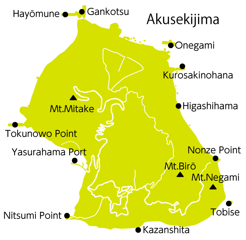 Akusekijima is a devout island surrounded by steep cliffs. It enshrines the masked deity Boze, as well as countless other gods to which the islanders pray for day-to-day peace. Even the lush subtropical vegetation covering the island is carefully protected and revered as a “holy mountain.” Akusekijima is also home to many hot spring spas. A 20-minute walk from the port, near the shore, is Yudomari Onsen with separate baths for men and women, a hot spring welling up from coastal rocks, and a geothermal steam sand bath.
Kodakarajima
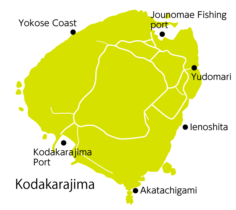 Kodakarajima is a small island with a circumference of about 4 kilometers, formed by raised coral reefs and situated some 16 kilometers northeast of Takarajima. The climate is typically subtropical, with thick growths of screw pine and sago palm, and hibiscus blooming by the roadside. The flat island—the tallest peak stands only 103 meters above sea level—can be circled in about 30 minutes by foot, and the view from above brings to mind an expecting mother. The coastline is dotted with fantastically shaped rocks called tachigami, among them the Unegami and Akatachigami being the most impressive.
Takarajima
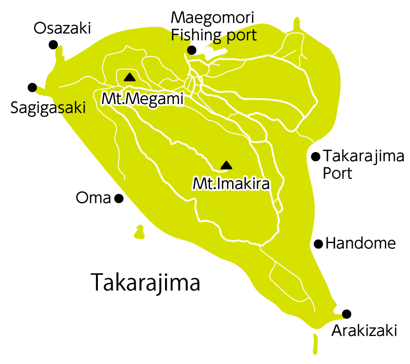 Takarajima is the southernmost inhabited island of the Tokara archipelago, formed by raised coral reefs into a heart shape. As the name “treasure island” suggests, Takarajima is a legendary destination of the Scottish pirate Captain Kidd, and the home of a limestone cave where Kidd is believed to have buried his treasure. History says countless adventurers and bounty hunters have actually visited Takarajima, both from Japan and from foreign countries, adding to the romantic legend of the “treasure island.” The emerald green of the coral reef coastline shines in beautiful contrast with the white sandy beach.
Getting to Toshima Village
Access
Access to the islands is provided, as a rule, only by twice weekly trips of the village-operated Ferry Toshima, and by water transportation running between Kagoshima and the Amami Islands. Ferry tickets may be purchased at the Kagoshima Honkoku Port South Pier Passenger Terminal and Naze Shinko Port (agent: Satomi Kaiun). On the islands, tickets are issued at branches of the village office. Note that ticketing times vary by island and are notified via the respective island announcement.
Ferry Toshima service
Naze Route timetable (starting April 1, 2017)

Ferry Toshima fare table (Unit: Yen)
Children are charged half of the adult fare (decimals are rounded up)
A student discount is available for second-class fares (20% off the adult fare)
Access to ports
| Kagoshima Honko Port South Pier |
|---|
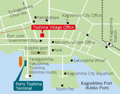 ◎From Kagoshima Airport: Airport bus to Kinseicho or Tenmonkan (15 min. walk) ◎From Kagoshima-Chuo Station: Streetcar to Izurodori (10 min. walk)
|
| Naze Port |
|---|
|
Berth location
Sadaikuma Quay
(Naze Sadaikuma-cho, Amami-shi) Ticketing location
(vehicle/cargo reception) Satomi Kaiun Sangyo K.K. Sadaikuma Office
2474 Naze Sadaikuma-cho, Naze-shi Tel. 0997-52-2251 Contact when above is unavailable: Tel.
0997-53-3111
|
Dining and shopping amenities
None of the Tokara Islands have city amenities such as restaurants, large supermarkets, or convenience stores. Visitors staying at a guesthouse will be served meals. However, visitors setting up camp are advised to bring an ample supply of food.